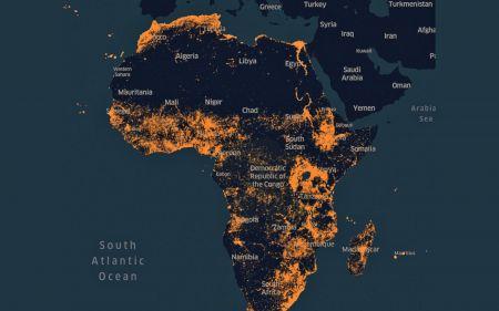
The American company Facebook has designed a detailed high-resolution map of Africa. It integrates population densities by region and area. The information was unveiled via a post published on April 9, 2019, on the company’s blog.
The map, it was carried out by researchers in artificial intelligence and data scientist of the Facebook office in Boston. It combines commercially available satellite images from DigitalGlobe with country-specific population census data shared with Columbia University’s Center for International Cooperation in Earth Science (CIESIN).
For accurate mapping, Facebook has cut the continent into several 30-by-30-meter zones so as not to simultaneously survey huge tracts of land, but scrutinize small portions accurately. Thus, every community, even the smallest, have been identified. Paths, geographical difficulties, etc.
Laura McGorman, public policy manager for Facebook’s Data for Good division, says the company’s innovation will be of great help in a variety of areas.
It will help humanitarian workers who are often struggling to pinpoint the location of small communities, to get medical help or to respond to disasters. “Accurate population density is undoubtedly the backbone of any public sector or social service intervention you can think of. Their existence means that organizations working in a range of foreign aid and poverty alleviation interventions will now have much more accurate maps for their work, “said Laura McGorman.
The card can also be used by telecom operators. They will be able to identify communities with high potential to install telecom equipment, taking into account geographical challenges for the routing of equipment.
For the national social services, this card can also be used for a better health policy, educational, etc.
Agence Ecofin
Leave a Reply